

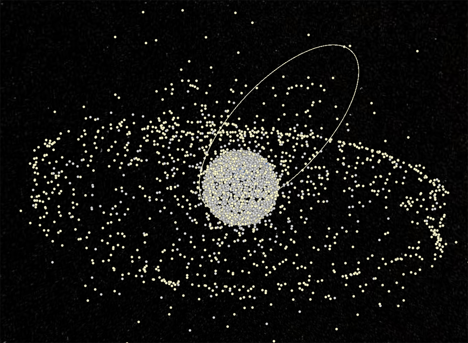
Tracking and analysing objects in Space through instruments positioned on the ground and through orbital space assets. This is the goal of Space Situational Awareness (SSA), which focuses on observing and understanding space objects, especially in Low Earth Orbit, the most overcrowded one.
focus
How Space observation
helps protect the Planet
Being able to monitor and understand what is happening in the Space environment, a more and more crucial domain for civil and military activities, is today essential for all States. Within this context, Space Situational Awareness and Space Domain Awareness activities emerge as fundamental to protect the security of Space and, with it, the Planet's one.
Low Earth Orbit (LEO)
Set of Earth orbits between approximately 200 km and the first Van Allen belt, at an altitude of roughly 2,000 km.
Medium Earth Orbit (MEO)
Set of Earth orbits between approximately 2,000 km and 35,786 km in altitude, at various angles to the equatorial plane.
Geostationary Earth Orbit (GEO)
Single circular and equatorial orbit at an altitude of 35,786 km (or 42,168 km from the centre of the Earth).
Activities related to Space Situational Awareness include object tracking, threat characterisation and analysis of the data collected. The use of Space Surveillance and Tracking (SST) systems allows SSA to be the crucial enabling factor for achieving effective Space Domain Awareness (SDA). SDA is a primarily military concept that signifies comprehensive awareness of everything happening in Space.
In the civil sphere, SSA focuses mainly on managing so-called unintentional threats, that is, space debris orbiting the Earth. This may include fragments of satellites, rocket components - called stages - originating from collisions or explosions (fragmentation), and non-operational or decommissioned satellites, which may in turn cause collisions with satellites that are still operational. We must remember the effects of space weather, such as solar flares, which can affect the space environment and related operations. When applied to civil scenarios, SST systems monitor and track such objects without needing to identify them to prevent collisions and ensure the safe and continuous operation of space infrastructures.
Space Weather
Discipline focusing on space-based physical phenomena, mainly originating from the sun, capable of generating significant impacts on the health of spacefarers and on technological systems in operational use.
In this context, Telespazio is developing for the Italian Space Agency an innovative Hardware and Software Infrastructure (HIS) for the processing of SSA data and the provision of Space Traffic Management services, located at the Matera Space Geodesy Center.The system will be able to provide alert services in the event of a possible collision between satellites (collision avoidance), fragmentation in orbit and re-entry into the atmosphere and also innovative services to support In-Orbit Servicing operational campaigns and for collision avoidance maneuver. IHS will interface ASI sensors installed in Matera already in use for space surveillance, such as the Spade telescope and the MLRO laser, and the future sensor network, featuring the Flyeye telescopes and the Space Debris observation station Laser Ranging.
In military terms, Space Situational Awareness must deal with intentional threats from hostile actors. These include spy satellites, anti-satellite missiles, and cyber or electronic attacks that aim to destroy or interfere with space systems and infrastructures. In such cases, it is also necessary to track objects, identify them, recognise them, and assess their hazard potential. Protecting space assets from these threats is crucial to national security and the proper conduct of military operations.
From Earth to Space
The heart of Space Domain Awareness and Space Situational Awareness activities lies in Command and Control (C2) systems which, also thanks to artificial intelligence (AI) algorithms, process and analyse data from sophisticated sensors, providing an integrated and real-time view of space activities.
In this context, Leonardo developed the Italian SST Operations Centre (ISOC) at the Aerospace Operations Command (COA) in Poggio Renatico (FE). This operations centre coordinates the use of the various national sensors to monitor Space to obtain a robust Recognised Space Picture (RSP), which helps identify orbiting objects and predict collisions.
Recognized Space Picture
The RSP is a 4D view that allows the operator to observe the current situation and move through time by several hours, both into the past and the future, to assess predictions on the orbital dynamics of objects of interest. It allows us to view of all objects currently in orbit around the Earth, including debris.
The activity of C2 systems, which allow raw data to be processed and transformed into useful information, is complemented by the sensors necessary to acquire the data itself in the first instance. Leonardo's different types of sensors—radar, optical telescopes, optical and infrared sensors, LIDAR (Light Detection and Ranging)—are crucial for tracking objects, collecting spatial data, and reducing dependence on third-party sources, such as foreign countries.
To this end, in December 2023, Leonardo and the Italian Ministry of Defence signed a contract to produce an innovative multifunction Active Electronically Scanned Antenna (AESA) radar designed for surveillance and defence against ballistic threats, which allows space observation and tracking of objects from the ground. This naval-derived radar is based on the KRONOS Power Shield. The latter, part of the KRONOS family, features an all-digital antenna powered by technology already proven in AESA multifunctional radars in service. The KRONOS Power Shield constitutes the individual element of the new architecture. It comprises “mini-radars” integrated to form an approximately 200-square-metre panel. The AESA multifunction radar, which reaches LEO, can generate a very high amount of data. The new tool aims to create a “catalogue” of objects so that Italy, too, will have the capacity to generate data currently obtained from other catalogues or, to a lesser extent, from sensors with more limited functionality.
From Space to Space
If, at present, most sensors for space surveillance and security are ground-based, the challenge for the future is to transfer and integrate these technologies into Space-based assets, ensuring and enhancing observation capabilities directly from Space. Through Thales Alenia Space, Leonardo develops and operates satellites with advanced sensors for observing and tracking space objects. These satellites can be equipped with space-borne systems, such as radar, optical, infrared, and LIDAR sensors, which can be used to track the position and movement of other satellites and monitor the behaviour of space debris directly from Space.
This is the background to the European EMISSARY (European Military Integrated Space Situational Awareness and Recognition Capability) project, led by Leonardo and financed under the European Defence Fund. Involving 28 industrial partners, 12 small and medium-sized enterprises, five universities, and research institutions from 13 European countries, it aims to enhance the surveillance of the space domain at the European level. The goal is to develop a network of sensors (radio frequency and optical) and a Command-and-Control system to support multi-domain operations. The development of ground- and space-based sensors will enable the detection, tracking, identification and characterisation of space objects in LEO, MEO and GEO.
What future for Space Domain Awareness?
Data management and processing, through tools with advanced processing capabilities, are essential aspects of a complete and effective SDA. This is why disruptive technologies such as super-computing, cloud-computing and artificial intelligence play a decisive role in improving the quality and speed of the information generated by space data.
This is the basis for the Military Space Cloud Architecture (MILSCA) project, which TELEDIFE awarded to Leonardo in February 2024 as part of the National Military Research Plan (PNRM). The goal is to create a cloud architecture that provides government institutions and the national armed forces with high-performance computing and storage capabilities directly in Space by integrating supercomputers, AI and the cloud into a constellation of Earth-orbiting satellites engineered to be cyber-secure by design. A true Space Cloud, it can store over 100 terabytes of data generated on Earth and in Space on board each satellite in the constellation. Moreover, it can perform computations with a power exceeding 250 TFLOPS (250 trillion operations per second) in single precision, using advanced algorithms based on artificial intelligence, machine learning, and big data, autonomously communicating and exchanging data with other satellites.

The presence of a secure archive and processing system in Space will ensure that users have access to strategic elements— not only for Space Situational Awareness, but also for communication, Earth observation, navigation—anywhere and anytime, even in the most remote locations. This will significantly reduce data processing times, as data will be processed directly in orbit and provide real-time information.
The 24-month project is led by Leonardo and includes Telespazio and Thales Alenia Space. The first phase will involve defining the system architecture, while the second will culminate in building a digital twin of the satellite using the High-Performance Computing (HPC) davinci-1 together with the multi-constellation satellite terminal demonstrator, which will be used to simulate different application scenarios in a digital environment. These tests will precede a subsequent experimental phase, which, if confirmed, will lead to the deployment of a constellation of demonstration satellites in orbit.
